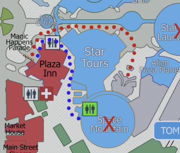
I've been drafting up a map of DL and DCA and like to draw out the path for my initial ride during Early Entry as in Grand Californian. In this case would be DL with Space Mountain. I have been modifying a 2D map as it's nice and flat for printing. That said, the map is sometimes hard to see where you can and can't walk as a noob. When I see videos of people walking to Space mountain at early entry Star Tours seems to be on their right as they walk there. However on my map it seems like it would be on their left. Is the red or blue path correct or something else?

Ignore the X thru Space Mountain. When I was going in August apparently it was going to be closed with a 1/4 of the park. Now moving it to December.
Also is the rope in the picture where we are held until 7:30AM? Further up? Back?
Thanks.
JR

Ignore the X thru Space Mountain. When I was going in August apparently it was going to be closed with a 1/4 of the park. Now moving it to December.
Also is the rope in the picture where we are held until 7:30AM? Further up? Back?
Thanks.
JR

