-
Controversial Topics
Several months ago, I added a private sub-forum to allow members to discuss these topics without fear of infractions or banning. It's opt-in, opt-out. Corey Click Here
You are using an out of date browser. It may not display this or other websites correctly.
You should upgrade or use an alternative browser.
You should upgrade or use an alternative browser.
TR June 2016 Uluru, A Spur of the Moment - Homeward Bound and end of TR on Day 8; 02/25
- Thread starter PrincessInOz
- Start date
dolphingirl47
In Search of the Tag Fairy
- Joined
- Dec 25, 2007
But it is an expensive part of Oz to get to so I can understand why you think you'll probably never get to see it.
The expense was not actually something we even considered. It is just that our vacation time is limited and this is so far away from everything else we would want to see when we finally make it to Australia properly. So I don't think we would be able to fit it in.
Corinna
dolphingirl47
In Search of the Tag Fairy
- Joined
- Dec 25, 2007
304 km of road beckoned and everywhere we looked, it was flat, flat and flat.
I am not sure I would cope with this too well. I do tend to get carsick.
The landscape looked straight out of Mars with all that red sand and the green shrubs/trees looked strangely out of place. There has been a bit of rain in the area lately, and there is a lot more green about than normal.


The green against the red looks stunning.
I was to find out later that the Station also offers meals and that it was worth stopping at for the meals. It even has a parrot aviary and an emu that wanders around. D’oh! Next time.
What a shame that you did not know about this before and missed it.

What an amazing view.

I love this photo.
an opportunity to experience the outback either by quad, helicopter or camel.
I am not sure which mode of transportation there scares me the most.
This is one of the deluxe classes of room at the resort.


I could get used to the idea of a jacuzzi with a view.
As the sun set lower, the glow turned to reds.


This is so beautiful.
So it came as a complete surprise when I had checked in last night to find out that a buffet breakfast had been included in our room rate. Really???
What a nice surprise.
Corinna
PrincessInOz
Thanks for my avatar, Mary Jo!
- Joined
- Feb 8, 2010
Sorry it was a disappointing start to the day, but yay for a surprise free breakfast! And FWIW I think your sunrise photos are beautiful!
Yes, those sunrise pictures were decent and it was a good morning for me at the time. It was actually disappointing when I got home and realised how little photos I took that morning! If I'd been a bit more awake, I would have snapped, snapped, snapped more!!!

Tough morning but your photos are still good. Breakfast looks nice and it is good to have free full breakfast.
Thanks, Bret. That breakfast was such a bonus!
The expense was not actually something we even considered. It is just that our vacation time is limited and this is so far away from everything else we would want to see when we finally make it to Australia properly. So I don't think we would be able to fit it in.
Corinna
I can understand that.
PrincessInOz
Thanks for my avatar, Mary Jo!
- Joined
- Feb 8, 2010
I am not sure I would cope with this too well. I do tend to get carsick.
We're even. I get seasick!
What a shame that you did not know about this before and missed it.
I'm tempted to head back again.....just to do Curtin Springs!!!
Sad to say it's a rare thing for me to see the sunrise on vacation so I enjoyed yours.
There will be a few more sunrises to enjoy.
")
Nice photos and room! I got a little behind on my own vacay, but being in a American port and waiting for lunch to arrive I had a little chance to catch up over here!
Thanks for checking in! Hope you're having a great time.
zanzibar138
DIS Veteran
- Joined
- Jun 30, 2007
Yes, those sunrise pictures were decent and it was a good morning for me at the time. It was actually disappointing when I got home and realised how little photos I took that morning! If I'd been a bit more awake, I would have snapped, snapped, snapped more!!!
I totally get that! Same thing happened to me in Shanghai
 Although I took hundreds of photos every day - I just somehow still managed to miss lots...
PrincessInOz
Thanks for my avatar, Mary Jo!
- Joined
- Feb 8, 2010
About King’s Canyon
Watarrka National Park is named after the umbrella bush (Acacia ligulata), known to the Luritja people as watarrka. This bush proliferates across the range and surrounding plains.

Kings Canyon is the central feature and prime attraction of Watarrka National Park. The canyon is effectively a massive gorge bounded by sheer cliffs up to 300m high. For the Luritja Aboriginal people that have lived in the region for more than 20,000 years, Kings Canyon is an oasis in a harsh environment, providing refuge from the hostile elements among the waterholes and shady gorges, and abundant food in the plants and animals that live here.

Explorers Ernest Giles and Samuel Carmichael were the first Europeans to traverse the region in October 1872. They found desperately needed water within the canyon and Giles named the creek after an old friend, Fiedler King; the range he named after his brother-in-law, George Gill, who helped fund the expedition. (Giles was followed a year later by William Gosse, who camped along Kings Creek before heading south to ‘discover’ Ayers Rock, which he named after the governor of South Australia, Sir Henry Ayers.)
There are a number of walks that you can do here. There is a short 0.5 km walk along the canyon floor. I’ve never walked this trail so I can’t provide any intel on this walk. There is also a 2-day hike from here to Katherine Spring along the Giles Track. It’s 22 km one-way and I haven’t even contemplated this walk at all!
We chose to walk the Kings Canyon Rim Walk this morning. The Rim Walk is rated by many as one of the best in central Australia for its diversity and spectacular views.

Why do I say we were late?
So hostile is this arid environment that national park authorities restrict access to the Kings Canyon Rim Walk during periods of hot weather. On days when the forecast maximum is 36°C or higher, the Rim Walk is closed after 9am. Even when the temperatures are not so high, there is very little shade on the walk and visitors should be wary of dehydration. It is best to start the walk early in the day and be well prepared with lots of water, a hat, sturdy shoes, sunscreen and snacks. And although you’re likely to encounter many other walkers on the track, this is remote country and emergency radios have been installed along the trail and at the car park, as well as first aid boxes at the top of the canyon. And these emergency facilities are used! The day before, a lady was helicopter-lifted out of the top of the canyon because she had tripped and broken an ankle. The warnings about starting early on the walk is generally well known and most people coming here start out at dawn! For us, it was 9.30 am when we started out. Just as well temperatures were in the low 20’s C.

(Continued in Next Post)
PrincessInOz
Thanks for my avatar, Mary Jo!
- Joined
- Feb 8, 2010
King’s Canyon Rim Walk (Part 1)
This 6km loop begins with a steep, 500-step climb of more than 100m to the plateau above the canyon. As the authorities specify that this trail can only be followed in a clockwise direction, there’s no avoiding this ascent.

As I started to head up, I was reminded of the passing of time. DH and I had been here some 18 or 19 years before. Then, there was no ‘paved’ steps up this hill. It was all slip rock. We had come as part of a tour bus out of Uluru and I remember skipping up with the bus driver. He did the climb every day and he and I got to the top without stopping and ahead of everyone else. Sadly, steps or no step, there’s no way I could skip up without stopping anymore.

There is a lookout with an impressive view down Kings Creek Valley and along the buttressed escarpment of the George Gill Range somewhere up this climb. Naturally, we (and everyone else) stopped to catch our breath. Looking up, we’re heading up to that escarpment.

On the other side, is the way down. And yes, irrespective of what the authorities want, you could go up that way. I believe they are a bit more relaxed about it in winter; but not so in summer.

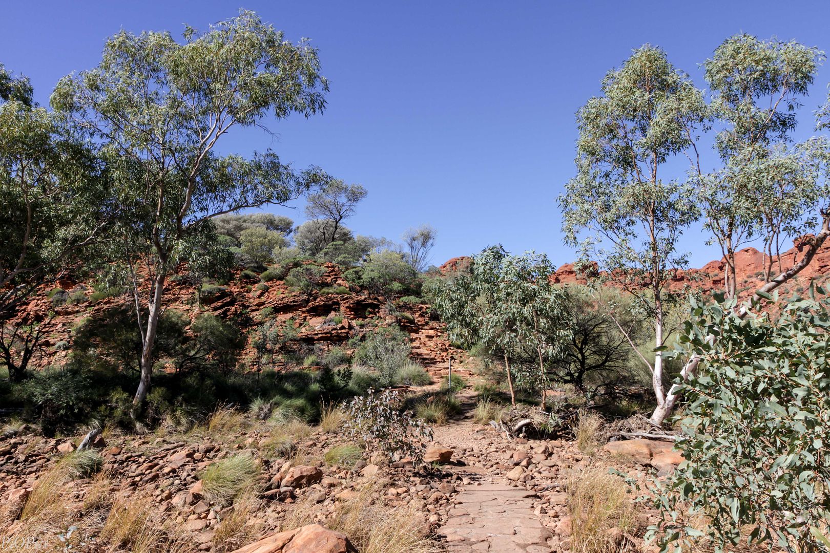
Once on the plateau, the trail is fairly easy. We walked along the path admiring the view....

.....and marvelling at the spinifex, white cypress and ghost gums.

It’s amazing how the gums manage to grow in seemingly little soil and the sides of the escarpment.

Every so often, there are vantage points that give a panoramic view. It’s pretty much desert out there.

The geology here is Mereenie Sandstone, a porous fine grained quartz sandstone. From the trail information, it seems that Central Australia was a windswept plain covered by sand dunes 400 million years ago. Over time, the sand compacted under the weight and silica laden water inundated the sand and cemented the grains together.
After a while, everywhere we looked, we could see this type of cross-bedding around us in the sandstone. Crossbedding is common in rocks that originated as sand dunes.

Another reason why I said we were late…..check out the colour on that sandstone. Apparently the stone glows oranges and red in the early morning light.

In any event, I was still pretty happy with the colour at noon.


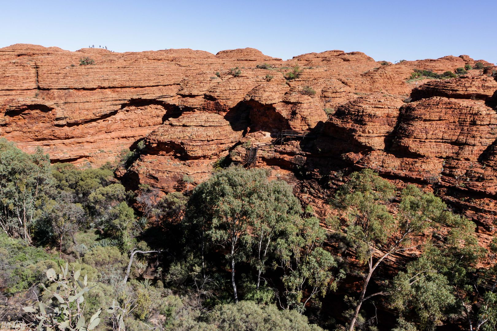
Near the top of the canyon, the track undulates through the Lost City, a maze of domed ‘beehive’ formations.


As the canyon walls get closer, we can see down to the Garden of Eden. Yes, there are people on that track.

We find a 600m detour follows a projecting spur to Cotterill’s Lookout, on some of the beehives, with vertiginous views into the canyon.

Yes, we took it.


Jack and Elsie Cotterill set up the first tourism venture in the area in 1960 when they built a tourist lodge called Wallara Ranch at Yowa Bore, 100km east of the canyon. In 1980, Ian and Lyn Conway took up 3200sq km of Crown Land to establish Kings Creek Station, adjoining what is now the national park, on which they created a successful cattle enterprise and tourist haven offering a station stay experience for travellers.
This bridge is named after Jack Cotterill. The original bridge was made of timber and sandstone and it collapsed into that crevice in 1991.

It’s vertical cracks like this that widen into canyons over time.

The view down the canyon from that lookout area is just magnificent.

The other side looks closer from this angle, doesn’t it?

But there still is a yawning gap between the two sides!

You will have to double back on this detour to get back to the main trail. One of my boys was ready to get going.

(Continued in Next Post)
This 6km loop begins with a steep, 500-step climb of more than 100m to the plateau above the canyon. As the authorities specify that this trail can only be followed in a clockwise direction, there’s no avoiding this ascent.

As I started to head up, I was reminded of the passing of time. DH and I had been here some 18 or 19 years before. Then, there was no ‘paved’ steps up this hill. It was all slip rock. We had come as part of a tour bus out of Uluru and I remember skipping up with the bus driver. He did the climb every day and he and I got to the top without stopping and ahead of everyone else. Sadly, steps or no step, there’s no way I could skip up without stopping anymore.

There is a lookout with an impressive view down Kings Creek Valley and along the buttressed escarpment of the George Gill Range somewhere up this climb. Naturally, we (and everyone else) stopped to catch our breath. Looking up, we’re heading up to that escarpment.

On the other side, is the way down. And yes, irrespective of what the authorities want, you could go up that way. I believe they are a bit more relaxed about it in winter; but not so in summer.

Once on the plateau, the trail is fairly easy. We walked along the path admiring the view....

.....and marvelling at the spinifex, white cypress and ghost gums.

It’s amazing how the gums manage to grow in seemingly little soil and the sides of the escarpment.

Every so often, there are vantage points that give a panoramic view. It’s pretty much desert out there.

The geology here is Mereenie Sandstone, a porous fine grained quartz sandstone. From the trail information, it seems that Central Australia was a windswept plain covered by sand dunes 400 million years ago. Over time, the sand compacted under the weight and silica laden water inundated the sand and cemented the grains together.
After a while, everywhere we looked, we could see this type of cross-bedding around us in the sandstone. Crossbedding is common in rocks that originated as sand dunes.

Another reason why I said we were late…..check out the colour on that sandstone. Apparently the stone glows oranges and red in the early morning light.

In any event, I was still pretty happy with the colour at noon.


Near the top of the canyon, the track undulates through the Lost City, a maze of domed ‘beehive’ formations.


As the canyon walls get closer, we can see down to the Garden of Eden. Yes, there are people on that track.

We find a 600m detour follows a projecting spur to Cotterill’s Lookout, on some of the beehives, with vertiginous views into the canyon.

Yes, we took it.


Jack and Elsie Cotterill set up the first tourism venture in the area in 1960 when they built a tourist lodge called Wallara Ranch at Yowa Bore, 100km east of the canyon. In 1980, Ian and Lyn Conway took up 3200sq km of Crown Land to establish Kings Creek Station, adjoining what is now the national park, on which they created a successful cattle enterprise and tourist haven offering a station stay experience for travellers.
This bridge is named after Jack Cotterill. The original bridge was made of timber and sandstone and it collapsed into that crevice in 1991.

It’s vertical cracks like this that widen into canyons over time.

The view down the canyon from that lookout area is just magnificent.

The other side looks closer from this angle, doesn’t it?

But there still is a yawning gap between the two sides!

You will have to double back on this detour to get back to the main trail. One of my boys was ready to get going.

(Continued in Next Post)
PrincessInOz
Thanks for my avatar, Mary Jo!
- Joined
- Feb 8, 2010
King's Canyon Rim Walk (Part 2)
If you do walk, check out the floor. There are ripple marks in the rock floor here. The ripple marks were preserved in the lower layers of the Mereenie Sandstone. They are evidence that there were shallow lakes at Watarrka millions of years ago.

About halfway around the loop, the trail descends a wooden staircase....


.....into the Garden of Eden. It’s a narrow gorge with the kind of green you’d expect in a tropical or sub-tropical forest.

We walked past prehistoric cycads (Macrozamia macdonnellii) that spans over 50 million years of survival.....

....all the while, checking out the billabong type areas along this water way.

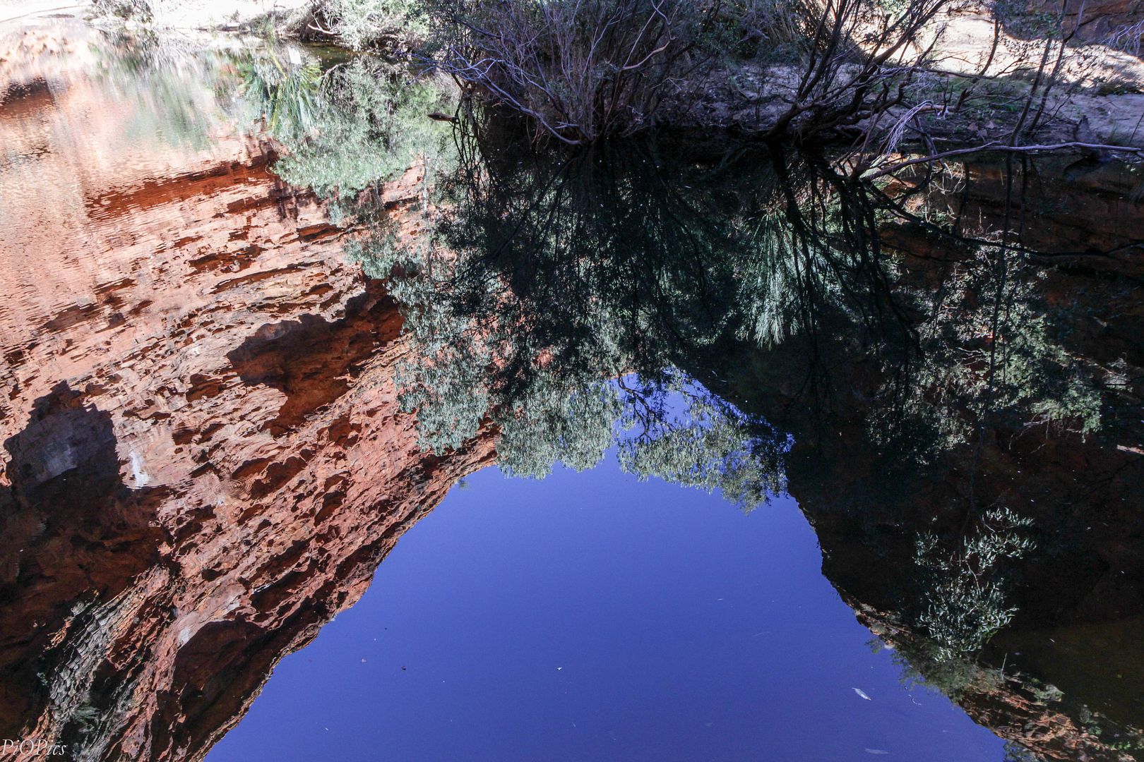
We eventually reached the end. An amphitheatre of vivid orange-red sandstone surrounding a large permanent pool.

The last time we were here, it was over 38 C and those were the days when visitors were still allowed to swim in the pool.

These days, swimming is banned. But it is still a wonderfully shady place for a break and to enjoy the oasis.
We headed back.

I overheard another group of walkers making an observation and had a chuckle. It might be a 300m distance to the end but it definitely is longer than a 300 m walk! With the stairs and the criss-cross between the sides of the gorge, I totally agree.


Another staircase climbs out of the gorge as the trail continues around the canyon’s southern rim on the return leg.


I didn’t realise it at the time, but this side is completely separate to the northern rim. There is a bridge that connects the two sides. If I had, I might have been a bit more diligent about capturing that bridge!

From the top of the staircase, the views back show the amazing landscape we had walked through. No wonder they call it the "Lost City"!

(Continued in Next Post)
If you do walk, check out the floor. There are ripple marks in the rock floor here. The ripple marks were preserved in the lower layers of the Mereenie Sandstone. They are evidence that there were shallow lakes at Watarrka millions of years ago.

About halfway around the loop, the trail descends a wooden staircase....


.....into the Garden of Eden. It’s a narrow gorge with the kind of green you’d expect in a tropical or sub-tropical forest.

We walked past prehistoric cycads (Macrozamia macdonnellii) that spans over 50 million years of survival.....

....all the while, checking out the billabong type areas along this water way.

We eventually reached the end. An amphitheatre of vivid orange-red sandstone surrounding a large permanent pool.

The last time we were here, it was over 38 C and those were the days when visitors were still allowed to swim in the pool.

These days, swimming is banned. But it is still a wonderfully shady place for a break and to enjoy the oasis.

We headed back.

I overheard another group of walkers making an observation and had a chuckle. It might be a 300m distance to the end but it definitely is longer than a 300 m walk! With the stairs and the criss-cross between the sides of the gorge, I totally agree.


Another staircase climbs out of the gorge as the trail continues around the canyon’s southern rim on the return leg.


I didn’t realise it at the time, but this side is completely separate to the northern rim. There is a bridge that connects the two sides. If I had, I might have been a bit more diligent about capturing that bridge!

From the top of the staircase, the views back show the amazing landscape we had walked through. No wonder they call it the "Lost City"!


(Continued in Next Post)
PrincessInOz
Thanks for my avatar, Mary Jo!
- Joined
- Feb 8, 2010
King's Canyon Rim Walk (Part 3)
We were heading back to the carpark now. I think someone was happy with that news!

Believe it or not, that's Cotterill's Lookout on the other side.

On either side of the canyon, the plateau has been sculpted by the elements into that maze of beehive domes of burnished red sandstone....

......interspersed with rock hollows. It was hard to avoid the hollows. We did a bit of walking up and down like this.

We even walked past waterholes! It's been about 3 weeks since the last rains, so I was surprised to see this still relatively full.

And everywhere we looked, we saw red. That sandstone was just stunning!

But dig a little bit beneath the Mereenie Sandstone veneer, there is yellow-white rock. Check out those white patches!

Apparently the colour is either from water carrying iron oxide, which deposits on the surface; or iron rich dust that has been fixed to the surface by fungus. Go figure!
We kept walking. There are more domes here than you can poke a stick at!

We walked right next to them.

And they are huge! Check out DS for a size comparison.

We eventually emerged at a point where we saw a sheer-sided canyon. From this angle, that rock formation looks ready to fall over.

Turns out, that's where Kestrel Falls bubbles down when there is water. Shame I missed it in the rain. It must be an impressive falls!

We kept going......

....and I kept seeing flowers. Seems like we're definitely in wildflower season here.


Down and down we went.

Until we eventually reached the canyon floor again.

This side of the walk is definitely less steep to climb and I did wonder why the authorities prefer you to walk up the other way. On reflection. I guess it's safer walking down a gentler slope than one that's a steep climb!
This was a great walk for us. Even DS was captivated by the scenery. In the end, we completed this walk in under 4 hours. Not bad, considering that we took every detour and stopped plenty of times for pictures.


We were heading back to the carpark now. I think someone was happy with that news!

Believe it or not, that's Cotterill's Lookout on the other side.

On either side of the canyon, the plateau has been sculpted by the elements into that maze of beehive domes of burnished red sandstone....

......interspersed with rock hollows. It was hard to avoid the hollows. We did a bit of walking up and down like this.

We even walked past waterholes! It's been about 3 weeks since the last rains, so I was surprised to see this still relatively full.

And everywhere we looked, we saw red. That sandstone was just stunning!

But dig a little bit beneath the Mereenie Sandstone veneer, there is yellow-white rock. Check out those white patches!

Apparently the colour is either from water carrying iron oxide, which deposits on the surface; or iron rich dust that has been fixed to the surface by fungus. Go figure!
We kept walking. There are more domes here than you can poke a stick at!

We walked right next to them.

And they are huge! Check out DS for a size comparison.

We eventually emerged at a point where we saw a sheer-sided canyon. From this angle, that rock formation looks ready to fall over.

Turns out, that's where Kestrel Falls bubbles down when there is water. Shame I missed it in the rain. It must be an impressive falls!

We kept going......

....and I kept seeing flowers. Seems like we're definitely in wildflower season here.


Down and down we went.

Until we eventually reached the canyon floor again.

This side of the walk is definitely less steep to climb and I did wonder why the authorities prefer you to walk up the other way. On reflection. I guess it's safer walking down a gentler slope than one that's a steep climb!

This was a great walk for us. Even DS was captivated by the scenery. In the end, we completed this walk in under 4 hours. Not bad, considering that we took every detour and stopped plenty of times for pictures.
zanzibar138
DIS Veteran
- Joined
- Jun 30, 2007
Wow looks amazing!
Aussie Wendy
DIS Veteran
- Joined
- Jul 4, 2008
It is fun comparing your trip now to our visit back in 2002ish and how some things have changed. You would have noticed the same. I seem to recall that few planes flew into Connellan airport back then or if they did they were super expensive so we did what most did and flew on a cheaper flight to Alice Springs. It would be fun to go back one day - maybe post retirement in a camper but while we are still active to do all the walks again! Kings Canyon was one of the highlights of the trip. We did the early morning climbing up around dawn.
dolphingirl47
In Search of the Tag Fairy
- Joined
- Dec 25, 2007
Kings Canyon looks stunning. I enjoyed all the photos. I can fully understand why they want you to go up the steep stairs. When I saw the photos of the stairs, I thought that I would struggle with those (I have issues with my balance and I am terrified of heights), but I think I could just about manage going up them. There is no way I could come down on them.
Corinna
Corinna
franandaj
I'm so happy, I could BOUNCE!
- Joined
- Nov 15, 2009
What a great hike. There's no way I could do something that strenuous, but it looks beautiful. All those stairs, crazy! I can't imagine what the original explorers faced!
What I find even more unbelievable is how much your son has grown! Is he taller than your DH now?
What I find even more unbelievable is how much your son has grown! Is he taller than your DH now?
WanderlustNZ
DIS Veteran
- Joined
- Oct 13, 2012
Looks like an awesome walk. I love the mix of dry, arid desert land interspersed with areas of lush greenery. Thanks for sharing. ")
PrincessInOz
Thanks for my avatar, Mary Jo!
- Joined
- Feb 8, 2010
Wow looks amazing!
I thought about you on that walk. I think it's something that you would enjoy!
The Kings Canyon Rim look so amazing. I am very impressed with you doing that tour and it looked fun to do especially with the picture taking.
Thanks, Bret. We all had a lot of fun on the walk. And the photo opps were great.
It is fun comparing your trip now to our visit back in 2002ish and how some things have changed. You would have noticed the same. I seem to recall that few planes flew into Connellan airport back then or if they did they were super expensive so we did what most did and flew on a cheaper flight to Alice Springs. It would be fun to go back one day - maybe post retirement in a camper but while we are still active to do all the walks again! Kings Canyon was one of the highlights of the trip. We did the early morning climbing up around dawn.
Wendy - you're absolutely right about this trip. It was familiar, but not at the same time. There were things that DH and I looked at and half-remembered how it was the last time we were here.
FYI - The price to fly to Uluru is now almost identical to the price to fly to Alice.
If you should decide to do the campervan thing, let me know! I might just meet you somewhere.
Beautiful pictures. But sad to say you would have lost me on that first bridge over the canyon.
I think you would have been okay!
Kings Canyon looks stunning. I enjoyed all the photos. I can fully understand why they want you to go up the steep stairs. When I saw the photos of the stairs, I thought that I would struggle with those (I have issues with my balance and I am terrified of heights), but I think I could just about manage going up them. There is no way I could come down on them.
Corinna
I suspect that's why the authorities recommend the one-way loop. It's definitely easier coming down the other side.
What a great hike. There's no way I could do something that strenuous, but it looks beautiful. All those stairs, crazy! I can't imagine what the original explorers faced!
At times, it felt like all we were doing was climbing up. Even after we climbed down to cross to the other side of the canyon, it still felt like we went up for some way before we eventually started to truly head downwards.
Yes....the original explorers would have been the Aboriginals. They would have had their trails and special sites.
What I find even more unbelievable is how much your son has grown! Is he taller than your DH now?
DS is nearly 16. Yes, he's taller than DH. Sadly for DS, he has short parents, so he's never going to be super tall.
*cough* *cough* DS is a little taller than even me!!!! *cough* *cough*
Looks like an awesome walk. I love the mix of dry, arid desert land interspersed with areas of lush greenery. Thanks for sharing.
Wanderlust....your family would love this part of the world. (Just not in the height of hot season.)
-
New D23-Exclusive The Phantom Menace 25th Anniversary Pin
-
Four Out of This World Star Wars Recipes for May the 4th!
-
Star Wars Pros: Take Our May the 4th Questionnaire Now!
-
Capture This Lightsaber Ignition & More Magic Shots in Galaxy's Edge
-
It's Almost Time for the New Storybook Land Additions Reveal at Disneyland Paris
GET A DISNEY VACATION QUOTE
Dreams Unlimited Travel is committed to providing you with the very best vacation planning experience possible. Our Vacation Planners are experts and will share their honest advice to help you have a magical vacation.
Let us help you with your next Disney Vacation!
Dreams Unlimited Travel is committed to providing you with the very best vacation planning experience possible. Our Vacation Planners are experts and will share their honest advice to help you have a magical vacation.
Let us help you with your next Disney Vacation!
New DISboards Threads
- Replies
- 3
- Views
- 52
- Replies
- 3
- Views
- 91